
a better city exists
Masterplans that help developers build lasting communities and long-term value.
We help developers build complete neighborhoods through street networks, land use, housing mix, and open space systems. Our work translates vision into implementation tools and smart phasing, so each phase feels complete, market-ready, and part of a bigger long-term vision from day one. If you are planning a new community, let's talk. Take look at our work and reach out to us about your community.

First Forty Feet's co-founders have helped shape some of the most successful master planned communities across the US and Europe.

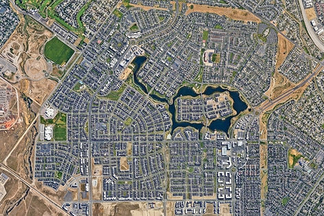
Daybreak
UTAH, USA
4,100 acres / 20,000 homes / mixed-use town center.
Parks, schools, and connected neighborhoods organized around a strong public realm.

Newquay
CORNWALL, UK
540 acres / 4,000 homes / schools + health + open space
A new community shaped through walkable streets, everyday services, and green infrastructure.

Prairie Trail
IOWA, USA
1,031 acres / 3,000 homes / civic + retail district
A complete neighborhood framework with housing, employment, and active public space.

Poundbury
DORSET, UK
400 acres / 2,700+ homes / employment + community facilities
An urban extension structured around mixed uses, walkability, and memorable streets.

Sherford
DEVON, UK
490 hectares / 5,500 homes / schools + district center
A long-term growth plan that integrates civic life, daily services, and open space.

Coed Darcy
WALES, UK
1,300 acres / 4,000 homes / retail + sport
A framework plan balancing housing, employment, landscape, and community uses.

Ellon
ABERDEENSHIRE, SCOTLAND
Major town expansion / mixed-use masterplan
A growth strategy with homes, employment land, school, community facilities, and open space.

Masterplanning Frameworks
We create master planning frameworks that organize streets, blocks, development parcels, open space systems, and neighborhood centers into a clear structure for growth. Our work helps developers align land planning, community character, and long-term value while establishing a practical framework for phasing, approvals, builder coordination, and delivery over time.


We design streets as part of a complete multimodal system that supports access, identity, and long-term value. Our street typologies address carriageways, parking, planting, sidewalks, and intersections, while also coordinating setbacks, frontage conditions, building placement, and neighborhood character. The result is a public realm framework that supports walkability, market appeal, and a coherent sense of place.

Housing & Mixed-Use Planning

We plan housing and mixed-use neighborhoods that support flexibility, market strength, and long-term livability. Our work helps developers organize a range of housing types, connect neighborhoods to mixed-use centers, and shape complete communities around a town center or civic heart. The goal is to create places that are walkable, adaptable, and strong in both daily life and market identity.
Builder Product Mix
& Frontage Guidance

We develop builder product mix and frontage guidance that helps multiple builders contribute to a coherent community vision. These tools align lot conditions, housing types, frontage character, and street relationships so individual products support the broader plan. The result is a more consistent place identity, clearer expectations for builder teams, and stronger delivery over time.
Public Realm Strategies

We develop public realm and landscape strategies that use parks, plazas, trails, streets, and planting systems to create value across a community. Our work helps developers shape open space networks that support walkability, access to amenities, neighborhood identity, environmental performance, and a stronger sense of place over time.
We think of public realm as both infrastructure and amenity. Connected parks, habitat corridors, trails, and civic spaces help each phase feel complete while giving residents immediate access to a larger community framework.


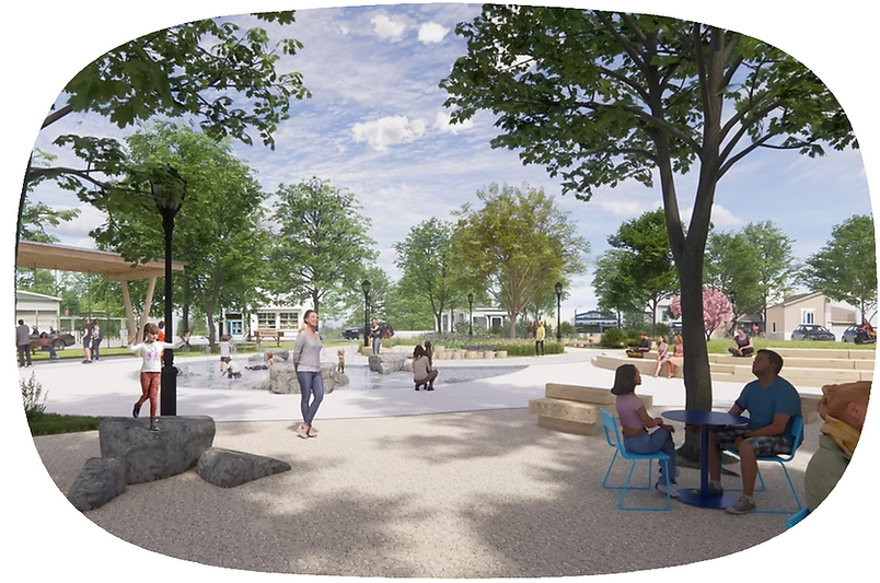
Neighborhood parks and plazas help create the everyday settings where community life takes shape.
Habitat corridors and trail networks can become meaningful amenities that connect nature, mobility, and identity across the plan.

Phasing & Implementation

We develop phasing and implementation strategies that help each stage of a community feel complete, connected, and market-ready from the start. Our work gives developers the frameworks, standards, and delivery tools needed to carry a clear vision across approvals, infrastructure investment, builder participation, and long-term buildout.

a better city exists
CERTIFICATIONS
Emerging Small Business (ESB)
Certification No.: 13469