
a better city exists
The Heights District Sub Area Masterplan
Project
Year
2022-2023
Location
Vancouver, Washington
Client
City of Vancouver, Washington

2023 Washington Governor’s Smart Communities Award
SMART VISION
The Challenge
Redevelopment of the former Tower Mall into an equitable 20-minute Neighborhood
The adopted Heights District Plan envisions a 20-Minute Neighborhood for Vancouver’s “mid-town” residents. It includes investments in multi-modal transportation (walk, bike, roll, and transit) and infrastructure improvements, such as redeveloping the former Tower Mall into a mixed-use, mixed-income neighborhood served by the Mill Plain Boulevard Bus Rapid Transit line (The Vine). The redevelopment will support 4,800 residents and feature a commercial “Main Street” with a Civic Plaza, Neighborhood Park, and the Grand Loop Linear Park—part linear park and part street extending through and connecting each of the neighborhood place-making features and the MacArthur Greenbelt. The Heights District Masterplan implementation builds on the sound planning principles of the 2020 Heights District Plan with an emphasis on ensuring that the new street network and future development support the use and function of public spaces such as the plaza, parks, and Grand Loop. It also focuses on inclusive design applications for all abilities within the project area streets, intersections, and public spaces, as well as methods to modify driver behavior that support safe walking, biking, and rolling to destinations such as schools, parks, open spaces, and area trails.


Inclusive Design
The design of the Project Area Streets was informed by research, analysis, and discussions with accessibility groups to identify challenges and opportunities for promoting walking, biking, and micro-mobility within the District and to transit. By using contrast, texture, audible messaging, and QR-coded wayfinding, the project team created a suite of intersection, sidewalk, and wayfinding design elements that ensure safe and accessible streets and public spaces for people of all languages and physical abilities.
The play features of the Grand Loop, Civic Plaza, and Neighborhood Park are part of the City of Vancouver’s Project Play initiative, which aims to install inclusive play experiences throughout the city. The design supports radically inclusive new playscapes for community members of all ages and abilities, offering access to physical, social, learning, and discovery-oriented play—the first facility of its kind in Washington.
Active
Place-making
Early in the infrastructure design process, the project team recognized that refining the adopted Heights District Plan could strengthen the core place-making elements. This included orienting the Civic Park to Divine Road to improve visibility and access to Mill Plain Boulevard, which would support street-oriented retail and activate the Civic Park on all sides. Additionally, extending the Grand Loop to MacArthur Boulevard would strengthen its identity and increase use by connecting to the Greenbelt’s planned walk and bike facilities. Finally, orienting the Neighborhood Park along Devine Road would allow the park to be activated on all sides.


The Impact
Gentrification and displacement are the most pressing fears facing this community.
The Height District has a diverse community, not only socially and culturally but also economically.
The Heights District Masterplan is implementing an anti-displacement strategy to prevent existing local businesses and residents from being displaced due to either new construction, cost of living, cost of services, or simply doing business. The city is coordinating new policies and actions that promote equitable development and reduce the harmful impacts of involuntary displacement on residents, businesses, and cultural organizations. The plan will promote economic development that supports local businesses and provides opportunities for new businesses to thrive. This includes supporting small businesses through access to resources and capital, promoting a diverse mix of retail and commercial uses, and encouraging the development of new job opportunities.

Fisher's Landing
Project
Year
2018-2019
Location
Vancouver, Washington
Client
Clark County Public Transit Benefit Area Authority (C-TRAN)

The Challenge
How to Go From a Park & Ride to a Transit Oriented Development
Transforming an existing CTRAN park-and-ride into a vibrant, mixed-use community, required reimagining a space once dominated by vehicular infrastructure into a people-centric neighborhood that supported housing, commerce, and community life. The key challenge was balancing the need for continued transit accessibility with the creation of walkable streets, public spaces, and a mix of residential and commercial uses. Integrating transit into the heart of a mixed-use development demanded thoughtful design that prioritized pedestrian mobility, fostered a sense of place, and promoted sustainable transportation options. The transformation also considered the neighborhood’s existing character while introducing new amenities to enhance livability, economic vitality, and social interaction. Balancing these competing priorities—mobility, community-building, and economic development—required a masterplan that seamlessly wove the site's past function with its future potential as a dynamic urban village.
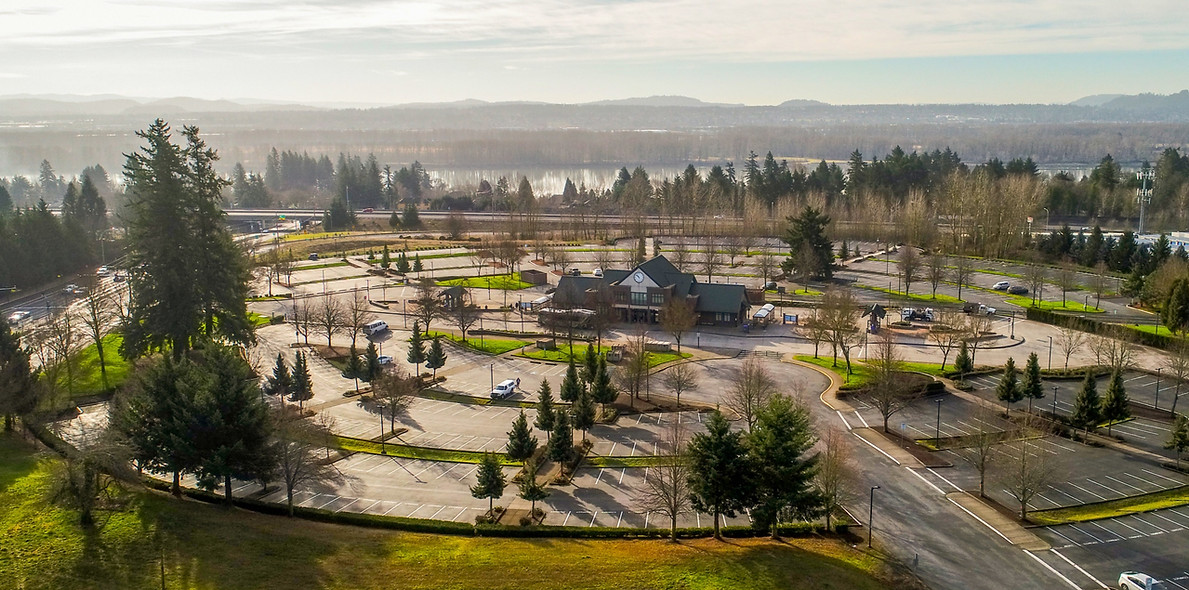
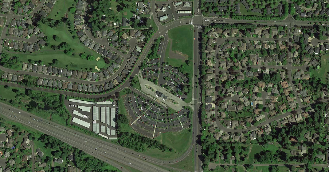
Today
CTRAN's Park & Ride currently provides hundreds of parking spaces for local residents to access transit into downtown Vancouver.
Trying Ideas
A handful of concepts were developed before landing on a plan which best prioritized people rather than cars in developing the transit oriented community.

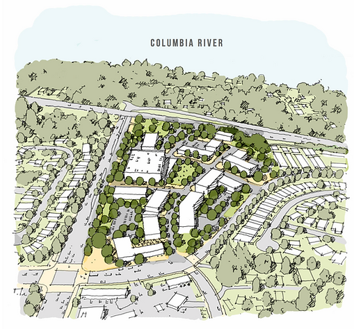
The Solution
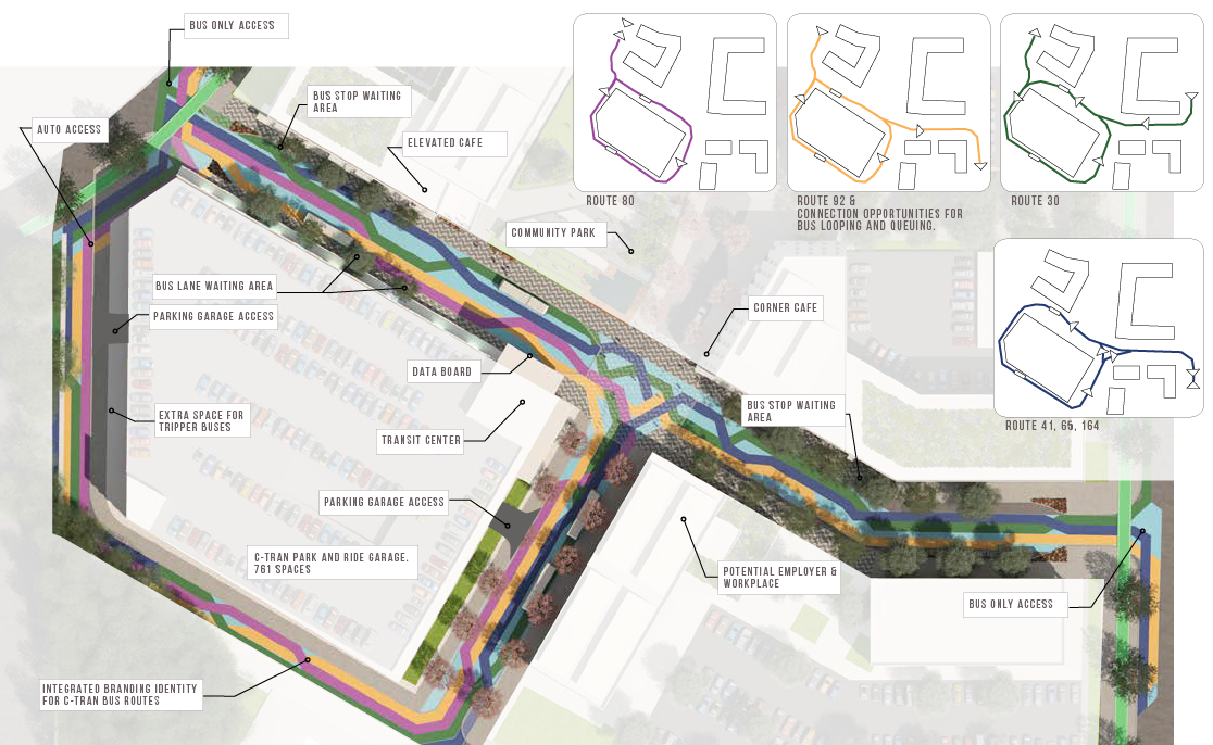
Creating a Vibrant Transit Hub at Fisher’s Landing
The aim was to enhance the transit experience by creating a destination design for people, integrating diverse land uses and community spaces to strengthen transportation systems. The plan accommodates future transit growth and increases ridership through development opportunities while providing diverse, mixed-income, and transit-supportive housing options. The goal is to create a new model of development suitable for the neighborhood with community support, celebrating the heritage of Fisher’s Landing and showcasing the significance of the plan in history. Additionally, the plan focuses on creating a strong network of complete streets to connect the surrounding community to new uses, services, and amenities, all while supporting
C-TRAN’s mission.
The Impact
A Vision for the Future
The proposed road network includes SE 162nd Ave as the main artery, a new road linking 164th Ave to Cascade Park Dr, and a reconfigured transit loop. The development plan features six street typologies to support diverse activities and encourages active frontages with food and beverage venues, outdoor seating, and playgrounds. The master plan includes a centrally located urban park, a wetland preserve, and a trail network. The reconfigured transit center supports a pedestrian-friendly environment with a new C-TRAN parking garage and a bus-only transit street. Key anchors include a Brew Hub and a Community Hub, enhancing visibility and economic success while connecting to Fisher’s Landing’s historical roots.
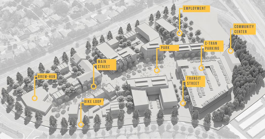
A Mixed Use Community:
The masterplan included a mix of uses, both public and private; a new park, main street, community center, food and beverage, a new transit center, offices, as well as a mix of affordable and market rate housing.
Transit Street Design:
The new transit street delineates the CTRAN's bus routes into and through the new community. The woven colors on the street represent the bus lines as they stop to queue and pick up new passengers.
Transforming park-and-ride lots into transit-oriented communities offers a comprehensive solution to many environmental and social challenges. It encourages sustainable transportation, efficient land use, improved quality of life, and economic growth, while helping to reduce the negative environmental impacts of car dependency and urban sprawl. By promoting smart growth principles, TOCs create a more connected, vibrant, and sustainable future for cities and their residents.
Design completed while at Ankrom Moisan. Copyright images - Ankrom Moisan
Westgate
Project
Year
2016-2018
Location
Beaverton, Oregon
Client
Rembold
Designed by James Brackenhoff & Will Grimm, while working at Ankrom Moisan Architects

The Challenge
New Transit Oriented Community
Creating a transit-oriented community at Beaverton Round, Oregon, posed challenges and opportunities tied to balancing density, connectivity, and livability. Situated adjacent to a MAX light rail station, the site offered excellent access to public transit but required thoughtful design to integrate this accessibility with a vibrant, mixed-use urban environment. These challenges included ensuring connections between transit facilities and pedestrian-friendly public spaces, fostering a mix of residential, retail, and commercial uses to generate around-the-clock activity, and addressing parking needs while minimizing reliance on cars. Additionally, the project had to overcome existing perceptions of underutilization and create an identity that attracted residents, businesses, and visitors while aligning with the City of Beaverton’s vision for equitable, sustainable, and inclusive development.

Two of the mixed-use project's within Beaverton Round were later called Westgate, which were designed by James Brackenhoff, while working with Ankrom Moisan Architects.
These were the two projects just north of the new hotel and west of the new Arts & Culture Center.

Outside
Interacting with the Street
Westgate's community amenities prioritize convenience and active lifestyles. Its bike rooms provide secure and accessible storage, encouraging residents to embrace cycling as a primary mode of transportation in the transit-oriented development. Additionally, shared spaces such as lounges, fitness facilities, and outdoor areas foster a sense of community, making The Rise Central not just a place to live but a hub for connection and sustainability in the heart of Beaverton.


Inside
Bike Rooms & Community Amenities
Westgate features secure bike rooms that promote active transportation and cater to cycling enthusiasts. Complemented by inviting community amenities like fitness spaces and shared lounges, it offers residents a vibrant, connected lifestyle.


Underground
Hidden Underground Parking
Locating car parking below ground was essential for maximizing land use efficiency and enhancing the urban environment. By moving parking out of sight, the design prioritized active ground-level uses, such as retail, pedestrian spaces, and landscaping, which contribute to a more vibrant and welcoming community. Underground parking also reduces the heat island effect, preserves valuable surface area for green spaces, and aligns with sustainable, transit-oriented development principles by encouraging multimodal transportation over car dependency.
Get in touch
Want to know more about this project?

.jpg)


a better city exists
CERTIFICATIONS
Emerging Small Business (ESB)
Certification No.: 13469